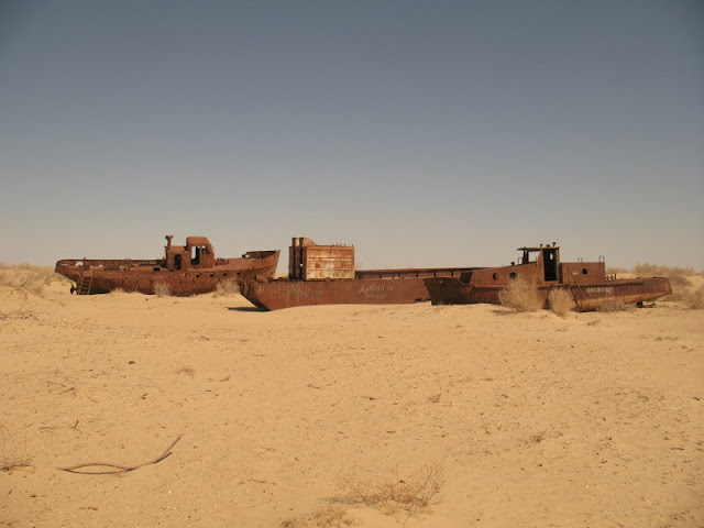
Aral Sea is an inland sea located in Central Asia between Kazakhstan and Uzbekistan in the north to the south, and the geography of the Arab Sea known algorithm.
Area of the Aral Sea was covering 68.000 square kilometers and a maximum depth of 68 m, and is the fourth largest sea in the world, separating the plateau Aust Orth and connected to the deserts of Kizbil com and the people of Nagorno-sand, which was hurt and Amodria Srdraa rivers and the many islands.
Solved Sea environmental problems are causing the drought a large part of this sea, most notably when the Russian government decided in 1918, converting two of the rivers feeding the sea in the north east of the country to try to irrigate deserts to grow rice, melons, grain, cotton and other crops, The plan was the most prominent is the cultivation of cotton "white gold" for export, with the result that the sea drought-stricken as of 1970, have begun to decrease the area gradually became in 2008 covering about 10% of its original size, and is expected if the situation continues as it is the sea will dry up completely in 2050. This set of pictures of the sea after the drought.
بحر أرال .. تعرف على المأساه التي حلت بأحد أكبر بحار العالم !
بحر أرال هو بحر داخلي يقع في آسيا الوسطى بين كازاخستان شمالاً وأوزبكستان جنوباً ، وعرفه جغرافية العرب ببحر خوارزم .
مساحة بحر أرال كانت تغطي 68.000 كم مربع ، وأقصى عمق فيه 68 م ، ويعد رابع أكبر بحر في العالم ، تفصله هضبة أوست أورت وتتصل به صحاري كيزبل كوم وقره قوم الرملية ، يصب فيه نهران سيردريا وأمودريا وفيه جزر كثيرة .
حلت بالبحر مشاكل بيئية وهي التي سببت في جفاف جزء كبير من هذا البحر ، أبرزها حينما قررت الحكومة الروسية في عام 1918 تحويل اثنين من الأنهار المغذية للبحر في شمال شرق البلاد لمحاولة ري الصحاري من أجل زراعة الرز، والبطيخ ، والحبوب ، والقطن وغيرها من المزروعات ، وكانت الخطة الأبرز هي زراعة القطن " الذهب الأبيض " من أجل التصدير ، فكانت النتيجة أن البحر أصابه الجفاف اعتبارا من 1970 ، وقد بدأت تنقص مساحته تدريجيا إلى أن أصبح عام 2008 يغطي حوالي 10% من مساحته الأصلية ، ومن المتوقع إذا استمر الحال بما هو عليه فسوف يجف البحر كاملاً عام 2050 .
وهذه مجموعة صور للبحر بعد الجفاف .


